The last time I used a map was on Friday in Exmoor National Park. We followed a circular route from Haddon Hill car park to Wimbleball Lake via Bury, the southern version. Having walked it a number of times, I wanted to deviate from the norm to check out a different route, dropping from Haddon Hill into the forest and approaching Bury from the right, on the south side of the River Haddeo.

The problem with maps, even Ordnance Survey ones, is I’ve yet to find one that is 100% accurate. The map revealed paths through the forest existed, but they were the of the black dot variety, which means there should be tracks, but they might not be public rights of way, or even match the layout shown on the map. In this case, it turned out to be both. As soon as we left the brow of the hill, the path we were following stopped matching its zig-zagging paper counterpart. Then, our way forward was blocked by a gate where the route was supposed to have led us downward to river level. Depicting paths through forests is almost impossible, especially in wooded areas where logging is taking place. Heavy machinery rampaging through the forest soon create their own tracks, so I don’t blame cartographers when the map doesn’t match up with reality.
Disappearing Paths
One time in Portugal, we found ourselves in an embarrassing situation when we were giving the director of the company we worked with a tour of the highlights of the company’s latest Portuguese walking holiday. He followed our route notes until we reached a junction shortly after starting out.
‘The notes say we should take the right fork here,’ he said, sounding confused. ‘But there’s no right fork.’
He wasn’t wrong. Andy and I had walked the route a couple of weeks previously and were convinced the notes were correct, but the landscape wasn’t. It was a complete mystery until, some weeks later, we walked the route again, bumping into a troop of Portuguese soldiers and their bulldozer creating ‘new’ paths in a bid to prevent fires from spreading.

Still, we trust OS Maps. If they show there are paths, then there should be paths. We ventured deeper into the forest, following clear and also not-so-obvious tracks until we pulled together the pieces of the path jigsaw and ended up exactly where we wanted to be. Irrespective of whether maps accurately depict path locations or not, they do show the direction we want to travel. That might sound obvious, but maybe only to people who can read maps. When I first learnt, it wasn’t by following paths, it was as-the-crow-flies stuff, irrespective of whether a path existed or not.
You won’t get lost with a decent map in hand. It’s the key to the countryside, any countryside, even a completely unfamiliar one.
A Library of Maps
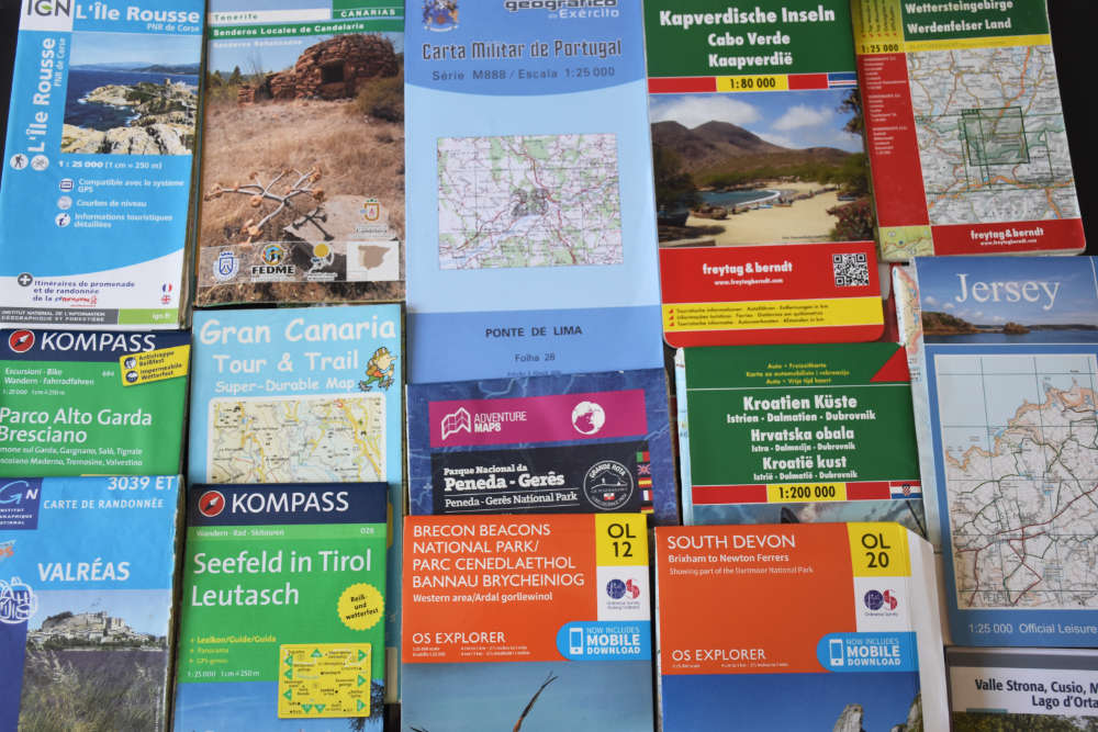
In the cupboard in my bijou office is a box full of maps from areas we’ve written self-guided walking routes for. There are German, Italian, Slovenian, Spanish, Portuguese, Italian, Croatian, French, Greek, British, and Austrian maps. Some are basic, whereas others are ridiculously detailed military maps. In Portugal, we used a mix of both.

On one occasion, when we needed to buy some maps for an area we were due to write routes for, we even had to visit an army camp in Lisbon (bizarrely tucked away in a housing estate), where we handed over our passports before being escorted to an office. Initially, we were treated with some amusement by the military staff – I mean, imagine a couple of foreigners turning up at a British Army base asking to buy some maps from them? But we got our maps. They were intricately detailed, but way out of date. Many of the marked routes no longer existed. I guess armed soldiers aren’t worried about some red-faced landowner telling then they can’t cross their property.
Some of our Italian maps were courtesy of a man we walked with above lakes in Northern Italy, gifted to us only if we promised to return and walk other routes with him. I’m ashamed to say, while we’ve been back to Italy many times since then, we haven’t returned to its lakes, so we’ve still to make good on the promise.

And that’s the thing about maps. They are more than magical keys for unlocking the wilderness. Every one of ours has memories attached. Some remain pristine, their robustness having shrugged of the elements. Others are weather beaten and battered, their creases held together by Sellotape, revealing more challenging weather conditions. I run my finger across routes we’ve followed in various countries, and they cease to be just coloured lines on paper; my mind fills with images of scenic spots, smells, experiences. Contours become undulating hills; blue lines transform into winding, sparkling rivers; and green strips burst into life, taking on the form of enchanting forests.
We use Google Maps/Earth, OS online, and various navigational apps. None come remotely close to provoking a similar sense of control and well-being as holding a paper map in my hand does.